
An enterprise-grade geospatial data management and delivery platform
What is Alto Data Management?
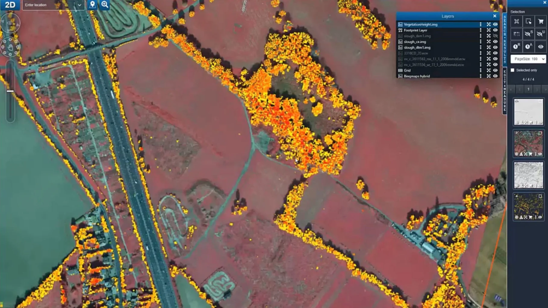
Octave Alto Data Management (formerly ERDAS APOLLO) is an enterprise-grade geospatial data management and delivery platform. It helps organizations identify, locate, secure, and organize geospatial and related business data into a searchable, secured repository for simple distribution.
Service-oriented architecture for large-scale enterprises
Superior performance with minimal hardware requirements
Read data in place, no conversion required
Alto Data Management Key Features
High-performance image streaming with ECWP
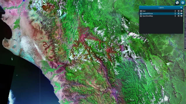
- Alto Data Management uses the ECWP (Enhanced Compression Wavelet Protocol) to stream large images and maps to end users at high speed. This protocol transmits only the pixels the user is currently viewing, saving network bandwidth and maintaining continuous workflow performance.
- ECW compression technology allows terapixel-sized raster imagery to be compressed into a single file, replacing the need to manage billions of traditional tile cache entries. This significantly reduces storage requirements and simplifies system operations.
- Alto Data Management serves thousands of concurrent user connections from a single standard server, even over slow internet connections. According to Octave, the platform requires less hardware and fewer pre-processing steps than any competing solution on the market.

Catalog Explorer for instant discovery
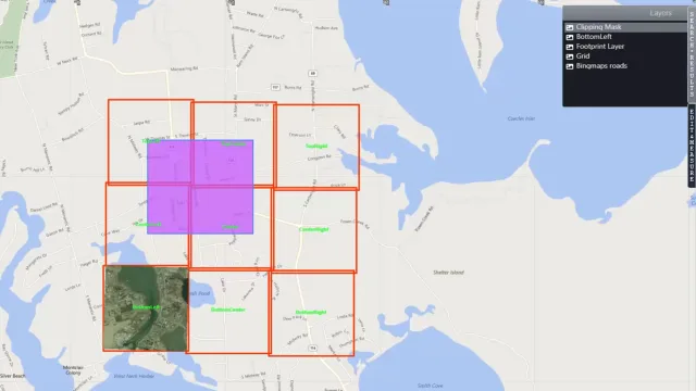
- Catalog Explorer is an integrated web client within Alto Data Management, enabling users to search the entire geospatial data library through a web browser. It functions as a dedicated search engine for geospatial information.
- Users can filter results by geographic location, date, keywords, and various metadata attributes. Catalog Explorer supports instant data preview before downloading, ensuring technical teams always work with the correct dataset.
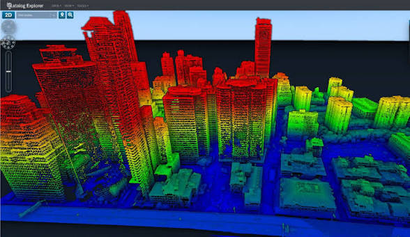
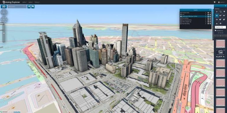
- The application is built on Octave Alto Browser (formerly LuciadRIA) visualization technology, providing powerful rendering capabilities. Catalog Explorer integrates diverse 3D delivery options from the server, including elevation sources, point clouds, 3D meshes, OBJ/BIM objects, and 360-degree panoramic imagery.
Server-side geoprocessing
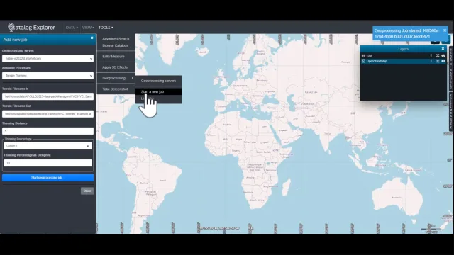
- Alto Data Management Geoprocessing Server empowers general users to create value-added data products by using spatial models built in advance by experts in Octave GeoMedia or Octave Imagine. Users need only a web browser and data sourced from the catalog to execute models.
- Server-side geoprocessing means complex calculations run on powerful server hardware closer to data sources. This produces outputs faster than running on individual workstations while ensuring consistent results across the entire team.
- Geospatial analysts can create custom models using Imagine or GeoMedia desktop tools and publish them to the Geoprocessing Server. Any user in the organization can execute these models on demand without direct specialist support.
Comprehensive 3D data management
- Alto Data Management extends data management beyond traditional 2D data. The platform provides comprehensive support for 3D data types including point clouds (LAS, LAZ, HSPC), 3D meshes (OBJ, OSGB), BIM/CAD models (DWG, DGN, IFC), and 360-degree panoramic imagery from E57 or Hexagon's Leica Pegasus sensors.
- All 3D data types inherit the foundational workflow and security model introduced with Alto Data Management Essentials. Data is discovered automatically through crawlers that locate, insert, and extract metadata without manual intervention.
- Alto Data Management solves the same core challenges for 3D data as it does for traditional vector and raster data: what does the organization have, where is it located, who can access it, and how can it be distributed to others. The platform maintains centralized governance regardless of data type.

Automatic data harvesting and cataloging
- Alto Data Management uses automated crawlers to scan designated folders, identify, and organize new files as they arrive. The system creates a live library that stays synchronized with reality at all times.
- Metadata harvesting runs on scheduled workflows, enabling organizations to maintain a centralized data repository without manual staff intervention. Alto Data Management supports harvesting all data types within a single crawler, including vector, raster, photogrammetry, and business data.
- Alto Data Management Studio is a completely redesigned web-based administration application, replacing the legacy Data Manager desktop tool. Studio supports all major existing workflows with vastly improved user experience, allowing administrators to access and configure the system directly from a web browser.

Open standards and interoperability
- Alto Data Management adopts OGC (Open Geospatial Consortium) interoperable formats and services as its primary, native implementation for data access. Services continue to interoperate with others, ensuring Alto Data Management can coexist with any existing platforms within the organization.
- Service APIs follow OpenAPI best practices, enabling seamless integration with non-spatial platforms. The product supports OGC WMS, WFS, WCS, WMTS, CS-W, OGC API Records, ECWP, and ISO 19115/19139 standards comprehensively.
- Alto Data Management integrates with existing enterprise database systems including Oracle, Microsoft SQL Server, and PostgreSQL. It can also be configured to use existing directory services for centralized security integration.
Enterprise security and access control
- Alto Data Management provides comprehensive security tools allowing administrators to control exactly who can view, edit, or download specific datasets. By setting clear permissions for different user groups, organizations protect information assets while ensuring everyone has the data access needed to complete their work.
- The integrated federated search system constrains search results to data assets the user has permission to access. This enables user empowerment without compromising operational security requirements.
- All newly harvested 3D and emerging data types inherit the foundational security model. Data is secured from the moment it enters the catalog, ensuring integrity and information security throughout the data lifecycle.
Three tiers to match every need
Alto Data Management offers three product levels, from a high-speed image server to a comprehensive data management system with analysis capabilities.
Alto Data Management Essentials
- Alto Data Management Essentials is the foundational platform for organizations needing enterprise-class management and distribution of traditional imagery and vector data. Building on its history of rapid imagery services, Essentials expanded its target market from version v2023 to cover all traditional spatial data types.
- Essentials provides a robust catalog model with expansive service support types, simple web administration, and an integrated security model for rapid yet secure delivery. The product supports vector (GML, Shapefile, FGDB), raster, photogrammetry, and business data formats within a single crawler.
- Supported service standards include OGC WMS, WFS, WCS, WMTS, CS-W, OGC API Records, ECWP, LTS, and ISO 19115/19139. Essentials also integrates geoprocessing and data extraction capabilities, including professional maritime, aviation, and weather standards.
Alto Data Management Advantage
- Alto Data Management Advantage adds point clouds, 3D meshes, and BIM/CAD data management to the catalog model. The product also expands support from traditional file-based data types to spatial data residing in databases such as Microsoft SQL Server, PostgreSQL, and Oracle.
- Defense industry users gain support for VPF, MGCP, and other defense-aligned formats and visualization standards. 360-degree panoramic imagery from E57 sensors or Hexagon's Leica Pegasus is also fully supported from the Advantage tier.
- All 3D data types inherit the foundational workflow and security model. Data is automatically discovered through crawlers for locating, inserting, and extracting metadata, enabling instant discovery or visualization after data is ingested into the system.
Alto Data Management Professional
- Alto Data Management Professional provides a powerful server-side geoprocessing solution using complex algorithms from Imagine and GeoMedia. Geospatial analysts create custom models using desktop expert tools and publish them to the Geoprocessing Server for on-demand execution by any user.
- Starting with version v2023, the Data Extraction Service builds on the geoprocessing execution model, expanding capabilities beyond the raster domain. Users can generate entirely new derived output datasets by injecting data through spatial models.
- Professional integrates all capabilities of Essentials and Advantage, adding the ability to run complex spatial analysis on powerful server hardware. Results are produced faster by leveraging servers closer to data sources compared to individual workstations.
Which industries use Alto Data Management?
A geospatial data management platform designed for diverse professional sectors.

Defense and geospatial intelligence
- Alto Data Management supports VPF (Vector Product Format) and MGCP (Multinational Geospatial Coproduction Programme) formats, along with defense-related visualization standards. This capability enables defense organizations to manage and distribute terrain data, maps, and satellite imagery according to NATO alliance and international standards.
- Federated search ensures sensitive data is visible only to users with the correct permission level. Alto Data Management integrates with centralized directory services for security management compliant with government information security standards.
- The platform supports centralized management of point cloud data, 3D meshes, and 360-degree panoramic imagery from Leica Pegasus sensors, providing comprehensive battlefield environment and tactical terrain awareness.

Maritime, aviation, and weather
- Alto Data Management supports professional standards for the maritime, aviation, and weather industries, enabling organizations to manage and distribute weather data, nautical charts, aviation maps, and environmental data according to international regulatory standards.
- Server-side geoprocessing allows on-demand creation of weather and environmental data products using pre-built analysis models. End users access standardized data through Catalog Explorer without requiring specialized tools.
- The ECWP streaming protocol ensures weather imagery and nautical charts are distributed rapidly to thousands of concurrent users, meeting real-time monitoring demands in air traffic control and maritime surveillance.
Urban planning and infrastructure management
- Alto Data Management manages diverse infrastructure data including DWG and DGN maps from CAD software and IFC models from BIM software. These formats are automatically harvested by the crawler, classified, and entered into the centralized catalog alongside traditional geospatial data.
- 3D mesh and digital city model management capabilities allow urban planning agencies to maintain a comprehensive view of the city space. Alto Data Management supports direct 3D rendering through Catalog Explorer with elevation, point cloud, and OBJ model data integration.
- The detailed permission system enables sharing planning data between departments within government bodies while maintaining strict access control over sensitive documents such as unpublished planning maps.

Oil and gas and energy
- Alto Data Management provides a centralized platform for managing satellite imagery, geological maps, and spatial data related to oil and gas surveys. Large raster datasets from seismic surveys and remote sensing are stored and distributed efficiently through ECW compression technology.
- Server-side geoprocessing enables geologists and geophysicists to run spatial analysis models on survey data without installing specialized software on individual workstations. Analysis results are produced faster by leveraging powerful server hardware closer to data sources.
- Alto Data Management integrates with Oracle and PostgreSQL database systems commonly used in the oil and gas industry, enabling spatial data management alongside business data within existing IT infrastructure.

Land administration and natural resource management
- Alto Data Management enables land management agencies to build centralized data repositories including cadastral maps, multi-temporal satellite imagery, and natural resource data. The automated crawler updates the catalog when new data arrives, ensuring information always reflects current conditions.
- Point cloud and 3D data management capabilities support terrain change monitoring, forest stock assessment, and land-use change tracking. Alto Data Management distributes this data through Catalog Explorer or standard OGC services for diverse applications.
- The permission system enables sharing land data between management levels from central to local government, while protecting unpublished survey data. Data is encrypted and access-controlled at the individual dataset level.

Environmental and climate change research
- Alto Data Management supports the management and distribution of multi-source, multi-temporal remote sensing imagery for studying environmental and climate change. Large raster datasets from Earth observation satellites are stored, compressed with ECW, and distributed efficiently via ECWP.
- Server-side geoprocessing enables researchers to create analytical data products such as forest cover change maps, urban heat maps, or environmental impact assessments using pre-built spatial models in Imagine or GeoMedia.
- Alto Data Management complies with ISO 19115/19139 metadata standards, ensuring environmental data is fully described according to international specifications. This feature is particularly important for multinational research projects and environmental reporting to government agencies.
Frequently asked questions
Yes. Alto Data Management is the new brand name for ERDAS APOLLO following Hexagon’s spin-off of its software division into an independent company called Octave. The product retains all core capabilities and is continuously upgraded. Existing ERDAS APOLLO customers can upgrade to Alto Data Management without data loss.
The platform supports a wide range of data types including: Vector (GML, Shapefile, FGDB), Raster (ECW, TIFF, JPEG2000), Point Clouds (LAS, LAZ, HSPC), 3D Meshes (OBJ, OSGB), BIM/CAD (DWG, DGN, IFC), 360-degree Panoramic Imagery (E57, Pegasus), and Defense formats (VPF, MGCP). Full support is available from the Advantage tier upward.
Yes. Starting with Alto Data Management 2025, the product provides full support on both Windows and Linux. Organizations can deploy on-premises or on cloud platforms according to their IT infrastructure strategy.
ECWP is a proprietary streaming protocol from Octave that transmits only the pixels the user is currently viewing rather than the entire map. This reduces bandwidth, increases response speed, and allows serving large numbers of concurrent connections. WMS transmits the complete map per request, making it suitable for lower-traffic use cases.
Alto Data Management Studio is a new web-based administration application replacing the legacy Data Manager desktop tool. Studio enables administrators to configure, monitor, and delegate administration of Alto Data Management directly from a web browser with vastly improved user experience.
The product has three tiers: Essentials (traditional 2D data management with catalog and basic distribution), Advantage (adds 3D data, spatial database support, and defense formats), Professional (adds server-side geoprocessing with custom spatial models). Each tier inherits the capabilities of the tier below it.
The product integrates with Oracle, Microsoft SQL Server, and PostgreSQL. Alto Data Management also supports integration with existing directory services for centralized security management and connects seamlessly with Octave Imagine and Octave GeoMedia through Catalog Explorer.
Catalog Explorer is a web client that works on modern web browsers including Chrome, Firefox, Edge, and Safari. Users do not need to install additional software to search, preview, and access geospatial data from Alto Data Management.

