Nền tảng phân tích không gian và mô hình hóa 3D toàn diện

Nâng cao hiệu suất xử lý tác vụ kỹ thuật chuyên sâu
Tích hợp các mô-đun bổ trợ mạnh mẽ nhằm giải quyết triệt để các bài toán đặc thù trong khảo sát và quản lý tài sản không gian
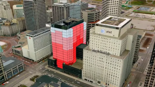
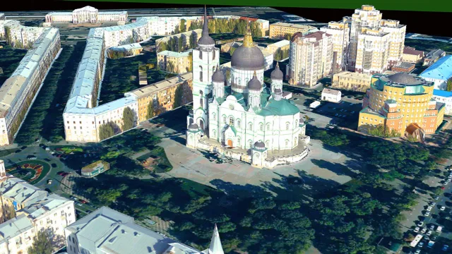
GeoMedia 3D
Tiện ích này cung cấp môi trường trực quan hóa ba chiều tương tác để người dùng khám phá mô hình địa hình thực tế. Công cụ hỗ trợ đắc lực cho công tác mô phỏng dự án và đánh giá tác động không gian trực quan.
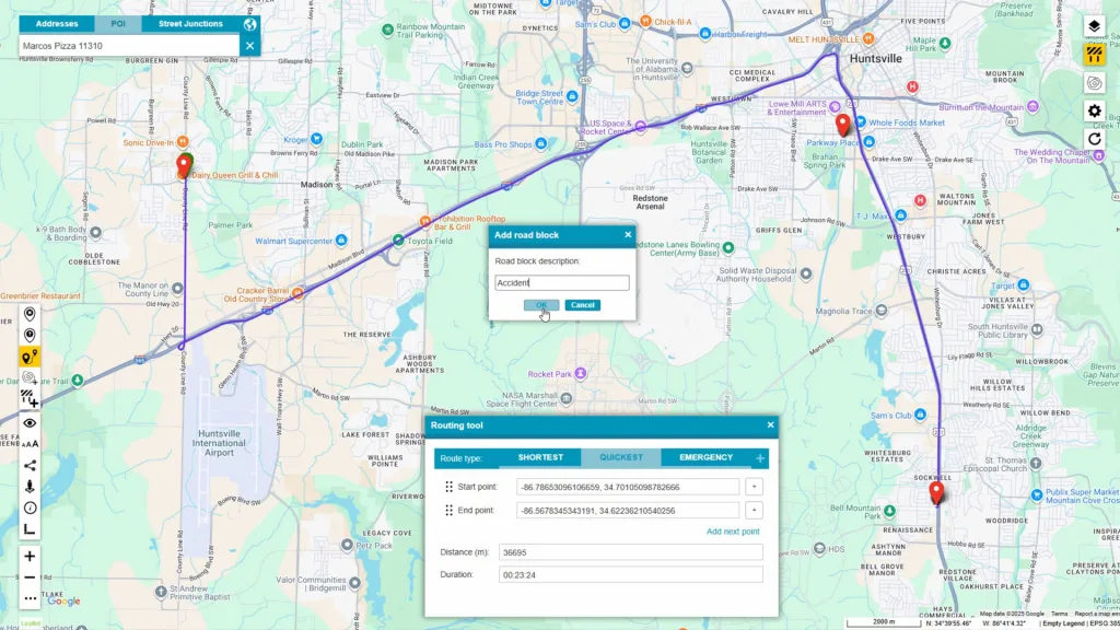
GeoMedia Transportation Manager
Giải pháp được phát triển phục vụ các cơ quan quản lý hạ tầng giao thông tuyến tính. Module này cung cấp hệ thống tham chiếu tuyến tính đa cấp giúp đồng bộ hóa hình học bản đồ với các dữ liệu sự kiện phát sinh ngoài thực địa.
GeoMedia Mapping Manager
Tiện ích hỗ trợ người dùng tự động hóa quy trình sản xuất bản đồ kỹ thuật số mức độ cao. Công cụ giúp thiết lập chuỗi bản đồ chuẩn xác phục vụ cho mục đích xuất bản chuyên nghiệp của doanh nghiệp.
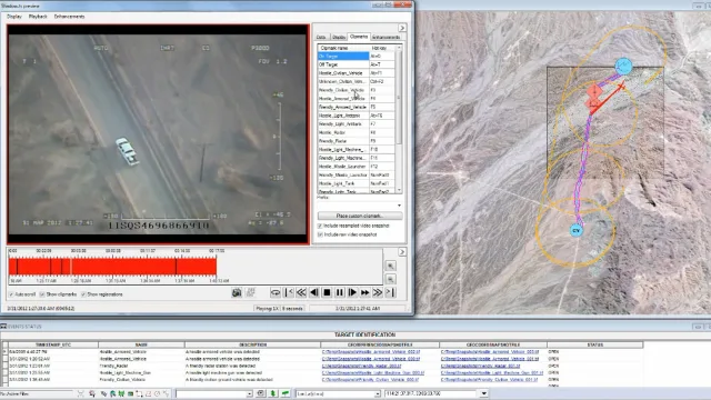
GeoMedia Motion Video Analyst Professional
Phần mềm cho phép kỹ sư tích hợp trực tiếp video chuyển động toàn phần vào môi trường không gian địa lý. Người dùng có thể dễ dàng phân tích kho dữ liệu video thu thập từ thiết bị bay không người lái để trích xuất thông tin.
Incident Analyst
Tiện ích phân tích và lập bản đồ dự báo xu hướng xảy ra sự cố theo cả hai chiều thời gian và không gian. Tính năng này hỗ trợ các cấp quản lý phân bổ nguồn lực ứng phó khẩn cấp một cách chủ động và chính xác nhất.
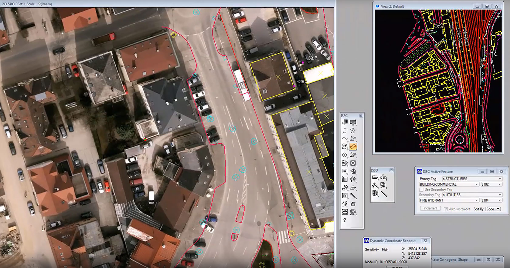
GeoMedia Image Professional
Giải pháp cung cấp các thuật toán nâng cao để tăng cường chất lượng hình ảnh trắc địa thô. Kỹ sư có thể thực hiện đăng ký tọa độ và trích xuất thông tin bề mặt từ ảnh vệ tinh với sai số thấp nhất.
Bộ công cụ GeoMedia Advanced Collection và GI Toolkit
Nền tảng chuyên biệt hỗ trợ thu thập dữ liệu hiện trường và sản xuất bản đồ quy mô lớn. Năng lực của giải pháp đảm bảo cấu trúc sản phẩm đầu ra đáp ứng hoàn toàn các thông số kỹ thuật khắt khe nhất của ngành.
GeoMedia PDF và VPF
Tiện ích hỗ trợ xuất bản các tệp định dạng PDF tham chiếu địa lý thông minh giúp phòng ban chia sẻ thông tin dễ dàng. Kỹ sư cũng có thể sản xuất hệ thống bản đồ số định dạng VPF tiêu chuẩn phục vụ các dự án hạ tầng quốc gia.
Tổng hợp thông tin địa không gian đa nguồn
Kết nối trực tiếp đến hệ thống cơ sở dữ liệu doanh nghiệp không qua bước trung gian
Tích hợp trực tiếp không cần chuyển đổi
Hỗ trợ hơn 300 định dạng dữ liệu
Cập nhật dữ liệu theo thời gian thực
Khám phá hệ sinh thái giải pháp không gian mở rộng
Tích hợp liền mạch các phần mềm chuyên dụng nhằm tối ưu hóa toàn diện chu trình quản lý dữ liệu
- Công cụ này giúp chuyển đổi khối lượng lớn hình ảnh hàng không thành bản đồ chuẩn xác. Phần mềm cũng hỗ trợ xử lý dữ liệu từ thiết bị bay không người lái để tạo mô hình độ cao chi tiết.
- Đây là bộ giải pháp kết hợp mạnh mẽ giữa Octave GeoMedia WebMap và nền tảng dữ liệu Portal. Hệ thống này giúp biến các dữ liệu không gian địa lý hiện có thành những ứng dụng web trực quan và dễ dàng thao tác.
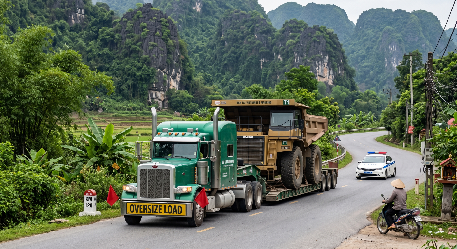
- Phần mềm chuyên biệt này giúp tự động hóa quy trình cấp phép và định tuyến giao thông dựa trên pháp lý khu vực. Nền tảng hỗ trợ quản lý lộ trình an toàn cho các phương tiện vận tải siêu trường siêu trọng trong suốt quá trình di chuyển.
Giải pháp chuyên biệt cho từng lĩnh vực công nghiệp cốt lõi
Giải quyết triệt để các bài toán kỹ thuật phức tạp và nâng cao năng lực quản trị tài sản cho doanh nghiệp
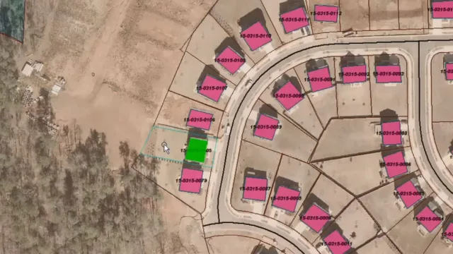
Lập kế hoạch đô thị và quản lý hạ tầng kỹ thuật
- Công cụ phân tích mối quan hệ không gian giúp chính quyền đánh giá chính xác mật độ xây dựng thực tế. Năng lực này giải quyết triệt để bài toán ùn tắc và hỗ trợ quy hoạch mạng lưới giao thông bền vững.
- Tính năng truy vấn theo thời gian hỗ trợ đắc lực việc kiểm tra tốc độ thay đổi của các công trình công cộng. Giải pháp mang lại cái nhìn toàn diện để cơ quan chức năng đưa ra định hướng đầu tư hợp lý.
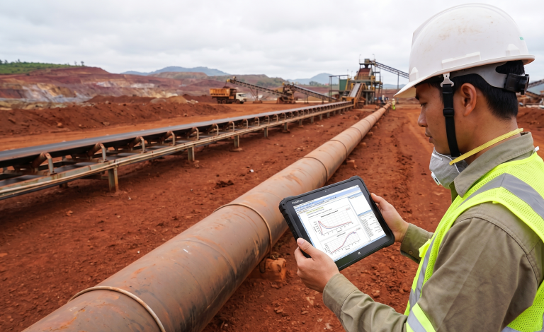
Ngành Năng lượng, Dầu khí và Thiết kế đường ống công nghiệp
- Tính năng quản lý mạng lưới tuyến tính hỗ trợ giám sát chặt chẽ hành lang an toàn tuyến ống dẫn dầu khí. Giải pháp giúp phát hiện sớm các điểm rủi ro và giảm thiểu chi phí vận hành doanh nghiệp.
- Hệ thống tham chiếu tuyến tính đa cấp cho phép đồng bộ thông tin thuộc tính kỹ thuật của đường ống trực tiếp lên bản đồ. Công năng này giúp bộ phận sửa chữa định vị chính xác vị trí khuyết tật ngoài thực địa.

Ngành Đo vẽ ảnh, Trắc địa công trình và Viễn thám
- Mô-đun ImageStation thực hiện việc chuyển đổi các nguồn ảnh chụp từ thiết bị bay không người lái thành mô hình cao độ chuẩn xác. Năng lực này giúp cung cấp nguồn tư liệu đầu vào đáng tin cậy cho công tác trắc địa.
- Sự tích hợp chặt chẽ với công cụ Spatial Modeler cho phép tự động hóa toàn bộ chuỗi tác vụ phân loại dữ liệu raster. Giải pháp giúp giải phóng sức lao động và rút ngắn thời gian hoàn thiện bản đồ địa chính.
Giải đáp các thắc mắc kỹ thuật về giải pháp Octave GeoMedia
Những thông tin quan trọng giúp doanh nghiệp thấu hiểu toàn diện về mô hình vận hành của phần mềm
Octave GeoMedia là phiên bản cập nhật và đổi thương hiệu chính thức của GeoMedia. Chức năng cốt lõi và hiệu suất vận hành của phần mềm vẫn giữ nguyên nhưng được làm mới về tên gọi cùng thiết kế nhận diện dưới thương hiệu Octave.
Phần mềm sử dụng mô hình cấp phép đồng thời hay còn gọi là bản quyền chia sẻ. Cơ chế này cho phép nhiều kỹ sư trong cùng một tổ chức dùng chung giấy phép một cách hiệu quả nhằm tối ưu hóa chi phí đầu tư ban đầu cho đơn vị.
Nền tảng sở hữu khả năng tùy biến rất cao cho phép người dùng tự do điều chỉnh giao diện đồ họa. Kỹ sư có thể ẩn các thanh công cụ không cần thiết để tập trung hoàn toàn vào quy trình làm việc đặc thù của dự án.
Hoàn toàn có thể. Cấu trúc sản phẩm được chia thành các cấp độ linh hoạt, kết hợp với hệ thống các chức năng mở rộng độc lập. Tổ chức có quyền lựa chọn tích hợp thêm các mô-đun như GeoMedia 3D hoặc Trình quản lý Vận tải khi có yêu cầu giải quyết các vấn đề chuyên sâu phát sinh.
TrueTech phối hợp chặt chẽ cùng hãng Octave để cung cấp dịch vụ hỗ trợ kỹ thuật tiêu chuẩn quốc tế cho khách hàng. Quy trình bao gồm việc xử lý sự cố vận hành, cung cấp các bản cập nhật phần mềm định kỳ và tư vấn trực tiếp từ chuyên gia.
Khởi động dự án số hóa hạ tầng địa không gian cùng TrueTech
Đội ngũ kỹ sư chuyên môn của chúng tôi luôn sẵn sàng đồng hành cùng sự phát triển của doanh nghiệp